Study Simulates Rising Seas in Grand Theft Auto V
Researchers used Grand Theft Auto V’s fictional Los Santos to model flooding under two emissions scenarios. The study found that the game’s landscape resembled documented flood patterns in Los Angeles, though its simplified model can overestimate the extent of flooding.
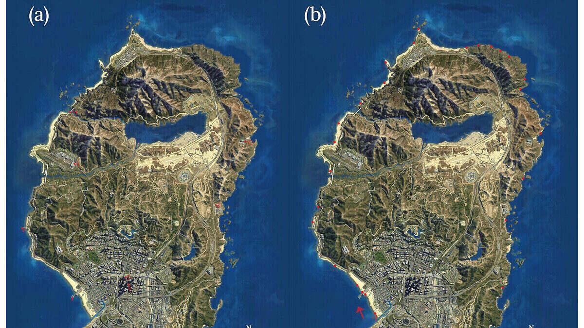
Researchers used Grand Theft Auto V to simulate rising seas in the fictional city of Los Santos, finding flood patterns similar to those documented for Los Angeles.
The study used the game’s detailed urban landscape to compare outcomes under high and low greenhouse gas emissions. Its authors say familiar virtual places could help players understand the effects of climate change.
Los Santos is modeled on Los Angeles. Researchers from the Alfred Wegener Institute and the University of Potsdam published their findings in Geoscience Communication.
“Abstract figures, maps and model projections of sea-level rise in centimeters or meters rarely convey the human impact of a flooded neighborhood or a familiar landmark,” said Hugues Lantuit of the Alfred Wegener Institute.
Two emissions scenarios compared
The researchers applied two scenarios from the Intergovernmental Panel on Climate Change across 2100, 2300 and 2500. One assumes effective climate protection; the other assumes very high emissions.
They added the highest water level ever recorded in Los Angeles, 1.59 meters (5.2 feet), to each scenario to represent a historical storm surge.
Under high emissions, the combined extreme water level reached 2.4 meters (7.9 feet) in 2100. It rose to 5.2 meters (17.1 feet) in 2300 and 8.2 meters (26.9 feet) in 2500.
In the long term, that scenario put 6.5% of Los Santos’s land area underwater. The coastline extended into the city center, submerging coastal towns and sections of the coast.
The city’s harbor, sewage treatment plants and gasworks stopped operating from 2300 onward. They were permanently out of service by 2500.
Under lower emissions, the extreme water level reached 2.1 meters (6.9 feet) in 2100 and 2.4 meters (7.9 feet) in 2300. It reached 2.6 meters (8.5 feet) in 2500.
The land area lost increased from just under 2% to 2.3%. The airport, port, sewage treatment plants and gasworks remained above water across all three time horizons.
Coastal towns still faced flooding in the lower-emissions scenario. Some beaches were almost completely submerged, along with adjacent roads for about two blocks.
Why the flood maps have limits
The model fills land up to a fixed water level rather than showing where water would actually flow. That approach tends to overestimate the extent of flooding, Lantuit said.
“The model fills the landscape with water up to a fixed level, just like a bathtub,” he said.
A comparison with documented Los Angeles flood risks showed similar spatial patterns in Los Santos. Lantuit cautioned that the game world is not an exact copy of reality and cannot replace a scientific elevation model.
Lead author Paul Nörenberg said familiar virtual surroundings could make climate impacts more relatable: “If this familiar, personally explored virtual landscape changes, players can engage with the effects of climate change on an emotional level.”
 Take the quizWhat Kind of Holiday Spender Are You? Take the Black Friday QuizStart →
- 1Gold Silver Price November: Futures Rise Near Yearly Lows

- 2U.S. Emergency Alert Test Nov. 17 Is Not a Power Outage

- 3Michael Clarke Says Sandpapergate Scars Drew Steve Smith to New York

- 42027 NFL Mock Draft Puts Ohio State’s Jeremiah Smith at No. 1

- 5Smith Urged Khawaja Not to Speak About Ball-Tampering Scandal
 Lifestyle · Food & Health4 Reasons to Eat Oatmeal, According to Nutrition Experts
 Lifestyle7 Signs Your Social Battery Is Running Low (and Why You Keep Cancelling Plans)
 Lifestyle · Food & HealthThanksgiving Food Safety: How Long Leftovers Last and the Safe Turkey Temperature
 Lifestyle7 Quiet Habits of Emotionally Intelligent People, According to Psychologists