Stone and water together shaped Arabia’s ancient settlements
A survey across the Rub’ al Khali found traces of ancient lakes but no stone tools, helping explain why early people did not settle its interior. Researchers…
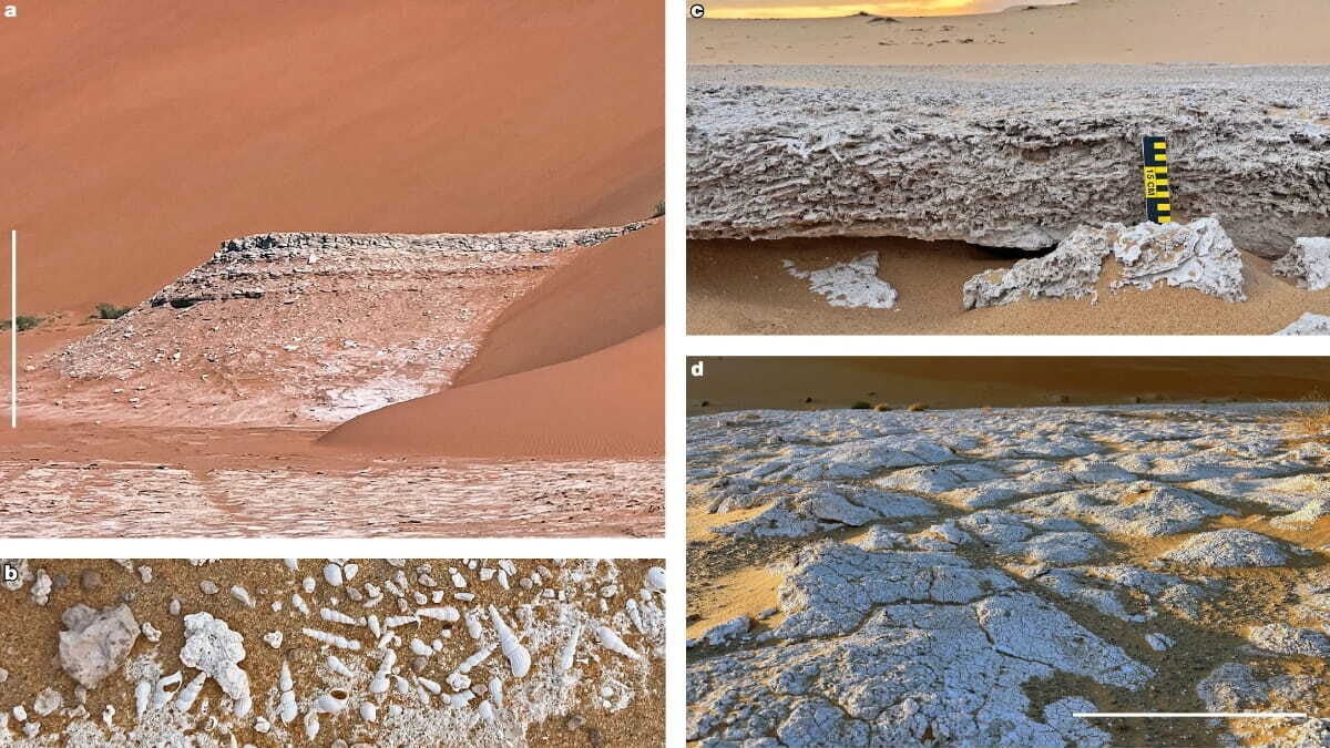
Early humans had access to freshwater lakes but left no tools in the Rub’ al Khali, and a new study says the desert lacked stone suitable for making them. Researchers at the University of Vienna and the University of the Algarve argue that stone and water together shaped where people settled in ancient Arabia.
The finding helps explain why wet periods did not draw people into the desert’s vast interior. The researchers surveyed 125 locations and found lake deposits at 55, alongside freshwater snail shells and ostrich eggshell fragments. Yet they found no tools.
Why did water alone fail to predict settlement?
Because nearby rock also mattered. The team’s computer model combined distance to water with the presence of stone that could be flaked into tools, then compared the results with 363 known Middle Paleolithic and Middle Stone Age sites.
Water alone predicted site locations with a score of 0.695 on a standard accuracy scale. Including workable stone raised the score to 0.768. The model’s central point is practical: a place with water could still be unsuitable for people who depended on stone tools if the local geology offered no usable material.
The field survey covered about 1,500 kilometers across the Rub’ al Khali. Eight researchers in three vehicles spent 35 days checking sites in late 2023. The ancient lakes formed between roughly 122,000 and 67,000 years ago, when monsoon rains filled the basin.
Ground visibility topped 95 percent, making chipped stone likely to stand out. Researchers found small amounts of raw material at 10 locations near the desert’s edges, but no artifacts at those spots either. The interior surface consists of carbonate and evaporite rock, which does not fracture into sharp edges. Groundwater fed the lakes, so rivers did not bring workable stone into the basin.
Where did people find the right conditions?
Archaeological sites from the same period occur around the desert’s margins, including Mundafan, Jebel Faya, Umm al Sha’al and the Dhofar Nejd plateau. The groups at those sites made tools from local stone.
That contrast matters for how researchers map ancient movement. Near water, 57 percent of the land sits on rock without knappable stone, the study says. Models that account for climate and water but overlook geology may therefore overestimate how much territory stone-tool users could occupy.
Carrying stone over long distances did not offer an easy substitute. Past studies cited by the researchers show that most tool material came from within about 5 kilometers. Sources more than 20 to 30 kilometers away usually supplied only 1 to 2 percent. The nearest stone was more than 200 kilometers from the surveyed lakes, too far to support routine toolmaking by a resident community across generations.
The researchers describe wet-period Arabia as a “lithic archipelago”: habitable areas shaped by geology as well as climate. They point to similar relationships in Libya’s Messak Plateau, Egypt’s Eastern Desert and Tibet. In central Oman, the opposite constraint appears: chert is abundant, but water is scarce and sites are few.
The team also notes limits to its findings. Geological maps use a coarse scale, and researchers identified shells from photographs. Future work could still locate small, short-term camps in the desert interior. The basin also remained without cultural material during the Early Holocene, when it filled with water again.