Australia Faces Severe Storms as Two Weather Systems Move In
Australia’s weather bureau has warned of severe thunderstorms across eastern states, with flash flooding, damaging winds and large hail possible. A cold front is expected to bring more rain and storms to southern states, while a tropical low develops off Western Australia.
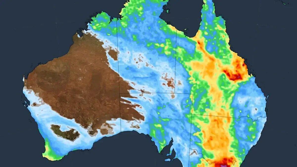
Australia’s Bureau of Meteorology has warned that two weather systems are set to bring thunderstorms across much of the country, with eastern states facing the greatest risk. Heavy rain could cause flash flooding in parts of Victoria and New South Wales.
Every state and territory could see thunderstorms. The bureau expects the most severe conditions across Queensland, New South Wales and Victoria, particularly in the southeast.
Flash Flooding Threatens Eastern States
The first system is drawing tropical moisture from the Coral Sea and Indian Ocean down the east coast. Weatherzone said that moisture will interact with an upper-level trough, producing rain and thunderstorms from the Top End to Tasmania.
In Victoria, heavy rain is the main danger across much of the state. Damaging winds and large hail are also possible in northern areas, the bureau said.
Showers are forecast to build in Melbourne during the morning, followed by storms and heavy rain into the evening. Some areas in northeastern Victoria could receive more than 50 millimeters.
Thunderstorms are forecast across most of New South Wales, with the exception of its northeastern corner. The most severe storms are expected in the west, where hail and damaging winds are possible.
The Riverina faces a particular risk of flash flooding. Some southeastern parts of the region, along with areas farther north and inland, could receive more than 50 millimeters, the bureau said.
In Sydney, storms are most likely in the western suburbs and toward the Blue Mountains. Canberra is also forecast to see storms.
Queensland Storms and Southern Cold Front
Brisbane and the Gold Coast are expected to avoid the initial storms, although severe thunderstorms could reach Queensland’s Channel Country and far southwest.
Some storms could form over recently flooded areas, bureau meteorologist Jonathan How said. “These severe storms could bring large hail, damaging winds as well as heavy rainfall,” he said.
How said isolated heavier falls could cause rivers to rise and flood some roads. Widespread rainfall is not expected in those areas.
Severe storms could continue over the weekend in southern inland Queensland, inland New South Wales and northeastern Victoria. How said storms could also move toward Sydney and the Illawarra.
A cold front approaching from the southwest is forecast to bring cooler, showery weather to South Australia, Victoria and Tasmania. Isolated damaging wind gusts are possible with the storms.
Tropical Low Could Become Cyclone
Off Western Australia, the bureau has given a developing tropical low a 25 per cent chance of strengthening into a cyclone over the weekend. If it forms, it will be named Owen.
The system is tracking southeast and currently appears unlikely to directly affect mainland Australia or the Cocos (Keeling) Islands.
 Take the quizWhat Kind of Holiday Spender Are You? Take the Black Friday QuizStart →
- 1Joachim Klement to Sell Stocks After S&P 500 Signal

- 2Brent Crude Slides 4.05% as Rising US Stockpiles Weigh on Oil

- 3Stock Market Today: Nasdaq Rises at the Open While Dow Holds Near Flat

- 4UnitedHealth Shares Fall 10.2% Amid Medicare Audit Proposal
- 5Stock Market Today: Nasdaq and S&P 500 Futures Rise Ahead of Anthropic Debut

 Lifestyle · Food & HealthWhat Is Raynaud’s Syndrome? Why Fingers Turn White in the Cold
 Lifestyle · Food & Health4 Ways Walking After Meals Helps Your Body, Doctors Say
 Lifestyle · Food & Health4 Reasons to Eat Oatmeal, According to Nutrition Experts
 Lifestyle7 Signs Your Social Battery Is Running Low (and Why You Keep Cancelling Plans)